Gingee Fort, also known as Senji Fort, is a structural display of might, known for being unfathomable, historic, and majestic. The citadel is situated atop three hills in the Villupuram district of Tamil Nadu, 150 km from Chennai. The Gingee fort complex has palaces, temples, pillared halls, a site museum, and underground tunnels within. A mere glance at the fortress, and one knows what strategic value this structure might hold as a witness to the rise, dominion, and then a fall of the kingdoms. Here is an account of Gingee Fort's history and rule, architecture, the associated myths and legends, and why one should visit it.
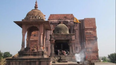
 A view of the famous Venkatraman Temple at Gingee Fort (Image source: Flickr)
The Gingee Fort has witnessed several reigns over the centuries, be it the Marathas or the Mughals, the Nayaks of Vijaynagar, the Cholas, the Sultans of Bijapur, or the French and later, the English. It became a prized possession, more so a strategic stronghold for the empires, serving as the 'nucleus of defence'[1].
According to the History of Carnataka Governors, the first fortification of Gingee was built in the 13th century by Ananda Kon, a political adventurer from the Shepherd community. He built a citadel on Kamalagiri (now Rajagiri) and named it Anandgiri[1].
Before this, Gingee had a modest beginning under the Chola Bastion, notably during the 9th century[3].
The Northern Hill was fortified by Ananda Kon's successor, Krishna Kon, in 1240 CE, called Krishnagiri. Next in succession, Kaneri Kon and Govinda Kon built further fortifications[1].
The Vijayanagar Empire: Some of the most notable constructions at Gingee took place under the Vijayanagar reign in the 15th and 16th centuries. Tubaki Krishnappa (Nayak or military chief of an assigned territory in the Vijaynagar kingdom), the founder of the Gingee Kings Nayak line, is believed to have built the surrounding walls of the hill forts, along with the Kalyana Mahal, several granaries, and a gymnasium. While the Venkatnarayanswami Temple was constructed by a succeeding Nayak, Muthialu Nayak[1].
The Vijayanagar Empire weakened gradually, and the Bijapuri Sultanate overtook Gingee by an invasion in the mid-17th century. Gingee was named Badhshahbad, where a Qiledar was appointed. It continued to be the strategic military base under the Bijapur Sultans for close to three decades[1].
After 28 long years under the Bijapuri Sultanate, Gingee was occupied by Maratha King Shivaji in 1677. The Marathas called the fortress, Chandi or Chanji. Shivaji led to the extensive fortifications of Gingee, with the construction of new ramparts, towers, ditches, guard rooms, barracks, and much more, all with a seeming perfection[1].
It took eight years of siege for Mughal Emperor Aurangzeb to capture Gingee from the Marathas, who ruled it for nearly 22 years when it also became their seat. Gingee was now Nusratgarh. Battles continued to occupy the fortress, which could happen only after Aurangzeb died in 1707. Gingee fell into the hands of Daud Khan, the new Nawab of Carnatic[1].
The European trading powers- the French and English had found a way to the coast, and Gingee was near to their settlements. The French took control of Gingee in 1750 CE from the Carnatic Nawabs[1].
The fortress was well maintained by the French, who added A royal battery (to store artillery and ammunition), and constructed two gates- Arcot Gate and the Pondicherry Gate[1].
Gingee was an important setting during the Carnatic wars between the French and English. Ultimately, in 1761, the English emerged victorious and Gingee slipped away from the hands of the French, and so did Pondicherry[1].
In between, during a brief period from 1780-99 CE, Gingee came under the control of Tipu Sultan. However, in 1799, after the Fourth Anglo-Mysore War, the British regained control of Gingee Fort, which remained with them till India's independence[1].
Post independence, the Gingee Fort has been declared a monument of national importance by the Archaeological Survey of India (ASI). It is maintained and administered by ASI only[2].
 Being one of the few surviving forts of the modern era, it can be said that the architecture has really stood the test of time! (Image source: Holidify)
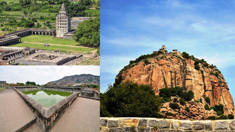
The Gingee Fort is designed according to its prestige and strategic significance: military importance, a location near the coast, as well as trade. The one that speaks of ancient grandeur and magnificent structures of stone. A large 60-foot wide rampart and an 80-foot moat encompass three hills, namely Rajagiri, Krishnagiri, and Chandrayam Durg (in the southeast). The three hills form the shape of a rough triangle, reinforced by fortifications around it. Each of them has a separate citadel with a few other structures[1].
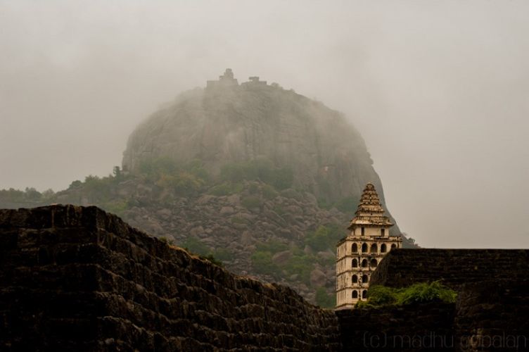
The tallest of the three is Rajagiri, or Anandagiri, or Kamalagiri hill (about 800m) to the west. A fortified path leads up to the hill. Rajagiri is separated from the surrounding area through a deep chasm (60 feet). A citadel is on top of the hill, with the Ranganatha temple. Shrines of Goddess Kamalakanni and Senji (part of the seven virgin goddesses worshipped in the region) are situated on the path of Rajagiri[1].
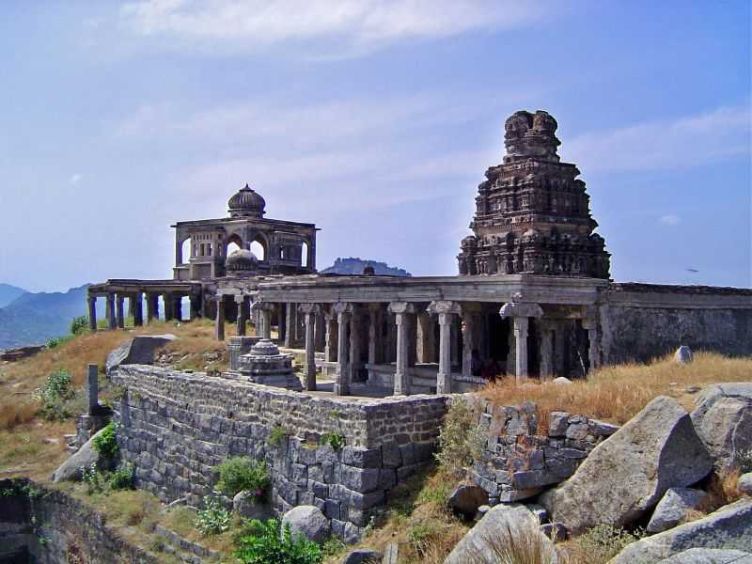
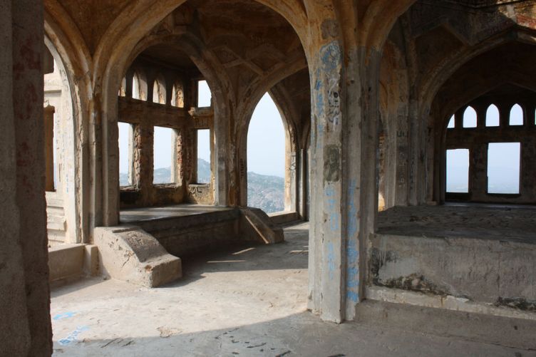
The Krishnagiri hill on the North, also known as the English Mountain, exhibits Indo-Islamic architecture in its construction, especially with what appears to be an audience hall (open, with a dome and beautifully carved arches). In terms of its strategic significance, it is very similar to Rajagiri. This citadel also has an empty sanctum of Lord Ranganatha[1].
The lower fort is enclosed within an area of 11 square km, which contains temples, mosques, pillared halls, and tanks. The Venkatanarayanaswami Temple, constructed during the Vijayanagar Empire, is situated in the Lower Fort. It has a beautiful doorway adorned with legends from the Puranas and other epics. Close to the temple, there are Anaikulam (The Elephant Tank), Chakrakulam, and Chettikulam tanks[1].
The inner fort area has the Kalyan Mahal, which is addressed as an 'architectural jewel'. It consists of a tower-like structure on a square platform, which has eight storeys with a pyramidal shikhara or summit. The platform is surrounded by several rooms where royal ladies must have resided[1].
A significant feature of the fort complex is that it had an abundant water supply, possibly because of the two perennial springs in Rajagiri[1]
Apart from the main hills, there is another small hill, known as Chakkili Durg or Chamar Tikri. The Chandrayan Durg and Chakkili Durg would have been fortified once, but they are just ruins now. All of these structures together form the Gingee fort complex.
Gingee hasn't been the same since the beginning; there are associated myths and legends that make it more of a mystery. According to historians, Gingee wasn't a complete fortification until the 13th century.
 How about an adventurous hide and seek trail in the walls of Gingee! (Image source: Tripoto)
For an avid history lover, an adventurous traveller who wants to unfold mysteries, and someone who has a yearning for cultural heritage, this place is just for you. Through architecture, one gets to see 'what would have been' in the bygone era, accompanied by tales of valor and chivalry.
Entry to Gingee Fort: Gingee Fort is open from 9:00 am to 5:00 pm. The entrance fees to Gingee Fort are minimal, quite cheap for Indian nationals. Check it[5]:
The best time to visit is during pleasant weather months from October to March[3].
If you are planning to visit Gingee Fort anytime soon, then here is a guide[3]:
By road: All the major cities of Tamil Nadu are well-connected to Gingee Fort. You can easily reach from Pondicherry (70 km), Chennai (150 km), and Bengaluru (250 km). Buses and private cabs can also be booked.
By train: The nearest railway station to Gingee Fort is Villupuram Junction, which is 40 km away. Then, you can take a bus or a taxi to the fort.
By air: The nearest airport to the fort is the Chennai International Airport, located at a distance of 150 km.
There are many other places to catch up near the Gingee Fort. Some of these are[6]:
| Place | Distance |
| Pondicherry | 71 km |
| Arulmigu Arunachaleswarar Temple | 35.69 km |
| Arunachala Hill | 36.8 km |
| Thiruvakkarai Fossil Wood Park - Geoheritage site | 38.13 km |
| Parvathamalai Top | 50.56 km |
| Ousteri Lake | 56.89 km |
| Auro Beach and Serenity Beach | 57+ km |
| Sathanur Dam | 58.77 km |
| Auroville Mothers Earth Temple | 52.57 km |
It's just the time to pack your bags and travel to this fascinating fortress, standing tall to the test of time. Make your way through the majestic past, layered in history, religion, culture, and mystery...Happy travelling, all!


_68076f11baa52.jpg)
_68076c94d462f.jpg)